We live in a world that is full of beauty, charm and adventure. There is no end to the adventures we can have if only we seek them with our eyes open.” – Jawaharlal Nehru
Beas Kund is one of the most ideal short treks one can undertake to enjoy the grandeur of Himalayan trekking. You don’t just get to witness a placid high altitude alpine glacial lake but also camp near the base of towering Himalayan peaks masked with snow and ice. Although most of the trekking companies offer at least a 3 day itinerary for this trek, if you are fairly fit and have done hiking before, one can easily complete this trek in 2 days or even a day.
The trek starts from Solang Nala (2483 Mts.), a valley extremely popular with tourists for its summer “adventure” sports like zorbing, skating, paragliding, horse riding, zip lining etc. In the winters, the giant slopes of the valley turn into a popular skiing destination. To reach Solang Nala from Manali, you can either hire a jeep/taxi or catch the 8.00 AM bus that leaves for Solang everyday from the Bus Stand near the Main Square. The 14 km ride takes about an hour over a fairly well maintained road dotted with countless shacks renting out snow boots and ski equipment. With plenty ofDhabas around, Solang valley will be your last chance to stock up on food supplies and beverages that you might want to carry into the trek.
The trail to Beas Kund crosses the Solang Valley and branches towards a small hamlet called Dhundi which lies about 8 kms North West. The entire 8 km stretch is on paved road and if you are lucky, you can hitch a ride on any of the numerous trucks that pass you going towards the construction site next to Dhundi. The South end of the famed 8.8 km Rohtang Tunnel which will make Leh accessible by road throughout the year is being constructed here and private and public vehicles are strictly prohibited from this entire stretch of road. Dhundi is the last village in the Solang valley and this is where Beas River meets its first tributary converging from Beas Kund and Rohtang Pass. With a brief stopover here and refilling your water bottles, the trail now heads West towards the camp site of Bakar Thach which is a comfortable 2 hour hike from here.
The trail is well trodden during summers and is a gradual ascent towards the meadows of Bakar Thach (thach means meadows locally). With the raging Beas River to your left and a plethora of blooming flowers in a variety of hues to your right, the hike only starts getting more alluring and enjoyable. Crossing the various streams on this trail can get a little tricky, at times requiring you to hop over from one slippery rock to another, or otherwise balancing yourself deftly over slender wooden planks placed by the shepherds. After about an hour, you should be able to spot some Gujjar huts to the left of the river. The trail then takes a sudden turn to the right and skirts around a small patch of hefty rocks and a tumbling waterfall, after which it takes you over a snow bridge to cross over to the other side of the river. When I did this trek in the middle of June, the snow bridge was still evidently strong as a large boulder was sitting in the middle of it. But as summer advances and days start getting hotter, there is a real risk of the snow bridge being weak and ruptured. When this happens, shepherds build a make shift bridge made of tree logs and wooden planks to facilitate crossing of the river. The trail then rises slightly and you will find yourself walking on the modest meadows of Bhoj Patra (meaning Birch trees) camp site with the Gujjar huts now directly behind you.
To the West, you will be able to spot the extensive hill of boulders that needs to be crossed to reach the Beas Kund Lake. Look behind and you might be able to steal a peek of the majestic Indrasan (6221 Mts.) and Deo Tibba (6001 Mts.) peaks. Keep following the trail that leads you towards the boulder field and in less than 30 minutes, you will reach the camp site of Bakar Thach. During the summer months, the Atal Bihari Vajpayee Institute of Mountaineering and Allied Sports, Manali (ABVIMAS), establish their base camp here to train aspiring mountaineers on snow and ice craft. If you prefer solitude and wish to set camp, you may want to return to the pastures of Bhoj Patrawhich is only a few minutes walk behind you. Bakar Thach (3270 Mts.) is a high altitude ‘shepherd field’ where the shepherds let their cattle and bovines graze during summers and a majority part of the monsoons.
The almost flat walk from the meadows of Bakar Thach gradually gives way to moraines and stray boulders deposited on river silt. As you approach the boulder field, the climb starts getting steeper. Sticking to the left bank of the enraged river, keep climbing from boulder to boulder till it allows you to cross the river. Now stick to the right flank of the boulder field and keep climbing which will eventually take you to a ridge. The way to the ridge is marked with systematically placed cairns. Cairns are a pile of delicately balanced rocks on top of boulders used to find your way through such mazes especially when the clouds are hanging low and visibility diminishes to all but zero. Thirty minutes into the climb, you should be approaching the ridge from where you get commanding views of the Beas Kund Valley to the West and the Bakar Thachcamp site to the South East.
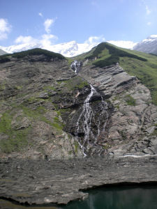
After a few minutes of traversing the ridge, turn right and now start descending the boulder field which will lead you to the Beas Kund Valley. It should take not more than 30 minutes to reach the wide flatland with various streams from all corners cutting across it. A lanky waterfall about 300 meters ahead of you might make you think you have reached the lake but it is just one of the many streams flowing down from the mountains carrying the melted waters from the glacier. Keep crossing the numerous streams and head towards the waterfall until the valley opens up. Spot the rightmost waterfall gushing down the flat slates of rock from a ‘green’ mountain and head in its direction to reach the lake. The lake remains illusory till the time you are almost directly upon it.
The pristine blue lake of Beas Kund suddenly reveals itself and it is this lake where it is believed that Rishi (sage) Vyas, the author of Mahabharata took his daily bath. The term Beas Kund seems to have been derived from Vyas, the sage, and Kund which in Hindi means a tiny lake. Dip your feet in the icy cold glacial waters of the lake and feel the fatigue slowly desert you!
With plenty of clearing all around, it was easy for me to find a place to set camp. The thought of spending the night surrounded by serene streams all around and the spectacular peaks of the Pir Panjal range on all sides was too magical to just let go. Hence, I decided to pitch tent about 200 meters from the lake for the night and return to Manali via Solang the next day using the same trail that got me here.
If you are short on time, it is quite possible to do this trek in 2 days like I did instead of 3 as is generally offered by trekking outfits. Camping at the Beas Kund valley is far more enticing and surreal than at Bakar Thach or Dhundi. But of course, this largely depends upon your fitness level too. I also didn’t feel any necessity for a guide as the entire trail was pretty well trodden and cairns did most of the job at the boulder field. I did not take a guide with me but met couple of shepherds at the Beas Kund valley and also some students from ABVIMAS at Bakar Thach. To go back, follow the same trail over the boulder fields down to Bakar Thach and then to Dhundi. From Solang, you can either get a bus or a taxi to Manali.
Some information about the trail:
Bus distance from Manali (1950 Mts.) to Solang Valley: 14 Kms.
Trek distance from Solang (2483 Mts.) to Dhundi – 8 Kms.
Trek distance from Dhundi (2840 Mts.) to Bakar Thach – 3 Kms.
Trek distance from Bakar Thach (3270 Mts.) to Beas Kund (3690 Mts.) – 3 Kms.
Major peaks seen on this trek: Shitidhar (5294 Mts.), Friendship Peak (5289 Mts.), Ladakhi Peak (5345 Mts.), Deo Tibba (6001 Mts.), Indrasan (6221 Mts.), Hanuman Tibba (5940 Mts.)
Gradient: Easy with few short steep climbs.
Best Season: May to October.


